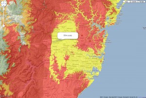
First image: The 80m level is the level at which the scarp west of Sydney pops out. It seems that 80m is globally significant in many places. Near Perth it also roughly marks the border scarp. On the east coast of the US, it’s a rough marker of the fall line, the demarcation between the Piedmont province and the coastal plain.
Others in the oil industry have noticed that 80m worldwide marks the boundaries of a lot of oil-rich provinces. Does that mean that there is oil around Sydney? Indeed, the lower Sydney formations do contain oil and gas (see Three Sisters: evidence for Noah’s Flood). Colours: yellow = 80m asl; red = 800m asl; Orange = 940m asl.

Third image: With the sea level at red = 80m, orange = 320m and yellow = 620m, the drainage now flows to the east, with 3 major water gaps appearing and flowing eastward. It also looks like there’s a secondary terrace around 320m, west of the 80m scarp.

The ‘chewed-up’ appearance is similar to the patterns in the western side of the Grand Canyon area which Scheele explained as the effect of ponded water draining into a lower sea. He gives a modern, small-scale analogue of this process and shows how it carves the dendritic, fractal, branching valleys back into the escarpments.
One of my colleagues commented on the sharpness of the escarpments, gaps and gorges in these images. The fact that they are so crisp and sharp and that we can easily trace the drainage flows means that the landscape is not very old. If it was exposed to tens of millions of years of erosion the features would be smoothed and not sharp.
Draining Condit Dam, Washington State, shows effects of receding floodwater
[…] the erosional remnant at C. All these features are common landscape features around Sydney (check Google images), indeed around the world. This video powerfully demonstrates on a small scale how they form […]