About the event, the commentary on the video says: “On October 26th [2011], a hole was blasted in the base of 125′ tall Condit Dam on the White Salmon River in Washington. In less than 2 hours, the reservoir behind the dam drained completely and the White Salmon flowed unimpeded by a dam for the first time in 100 years. This short clip is a combination of video and timelapse photography captured throughout the day.”
Rob Carter said, “The topic is interesting enough, but it gets exciting when the water level begins to reach the level of the upstream mud after ~ time 1:20.
“I know that there was a pre-existing river valley here, probably with hard rock walls, but a new valley was formed almost instantly in the mud. Huge blobs of mud are shifting downstream in a giant slurry as the water level drops.
“This was a slowly-deposited feature in a quiescent basin (the upstream lake), so there may not be many parallels to the inundatory stages of the Flood, but there are logs in that mud and old tree stumps are sticking out of the previous ground surface, re-exposed for the first time in a century.
“I see parallels here to many erosional features associated with canyons worldwide. What implications are there for catastrophic drainage of continents? Could it be that canyon formation was the last thing to happen as the Flood waters receded?”
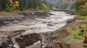
There are many interesting features in the main photo at the top of this page (taken from the video at ~ 1:32). At this point the dam has not fully drained and much erosion occurs after this. Nevertheless, there are some interesting features to notice in the image.
In the main photo above, notice the scalloped escarpments at A (letter is easier to see in the enlarged image). In the video leading up to this point we can see how quickly these escarpments formed. Notice the small amount of debris at the base of the escarpments. That is because the water flow that carved the wide ‘valley’ removed all the mud from the area. The water that emerged from the dam was black with mud. In the same photo above notice the water gap at B. Notice also the erosional remnant at C.
All these features are common landscape features around Sydney (check Google images), indeed around the world. This video powerfully demonstrates on a small scale how they form quickly.
Here is the video: