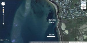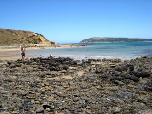
KEY SITE. Drive to San Remo over the Phillip Island Bridge and turn right into Back Beach Road toward Griffiths Point. At the end of Back Beach Road you can drive into the Lions Park and park around the road loop at the end. Access secluded Bonwicks Beach down the steps. (1 kilometre return ~1/2 hour)
There are a number of points of interest all within a few hundred metres of the stairs.
This is one of the three so-called KEY SITES identified in the excursion guide. By visiting and understanding these three sites you will have a good appreciation of the geology of Phillip Island and southern Victoria. The three sites are:
- Site 6—Pyramid Rock;
- Site 9—Cape Woolamai Beach and
- Site 13—Bonwicks Beach, San Remo.
These three sites are suitable for individuals and groups (such as a school excursion or church youth group). All three could be visited in a morning or afternoon.
Sandstone outcrops

These Cretaceous rocks along the beach from San Remo to Inverloch and beyond are famous for fossils of dinosaurs and part of the beach has been classified as a marine and coastal park. It is unlikely that you will find any dinosaur fossils, but you never know.
On the sandstone rock platform, look for the layers, or strata, and notice that they are dipping (sloping downward) slightly west toward the sea. In some places the beds are gently folded and inclined upwards into the bluff, while in others they form gentle arches.
Notice the pattern of jointing on the surface of the sandstone, how sets of joints tend to run parallel to each other and cut across other sets of joints dividing the surface into rectangles—like a pavement. Notice that within a few centimeters each side of the joints the sandstone has been stained brown as the result of iron-rich groundwater seeping through the cracks. Notice too that the iron stained areas often stand up higher than the surrounding sandstone because they are harder to erode. In some places the sandstone has been eroded forming interesting honeycomb patterns, possibly due to the effect of sea salt being absorbed into the sandstone and swelling, breaking the rock.
As you check the sandstone and the adjacent loose boulders you will find examples of strata that contain abundant pebbles and cobbles. There are many areas with lots of dark flakes of mud (rip-up clasts) enclosed in the sandstone. You may also find the black impressions of broken stems and twigs enclosed in sandstone (carbonized plant fossils). There are also examples of pieces of petrified (silicified) wood in many places, especially toward the bluff.

What is cementing the grains of sand together to form the hard rock? Silica is a common mineral that cements grains, likely precipitated from the same water that deposited the sand. Silica, also known as quartz, is a hard mineral that cannot be scratched with a knife. Iron minerals are also common cementing agents and these usually colour the sandstone red or brown. Calcite (which can be scratched with a knife or key) is another common cementing mineral. Where did this cement come from? The special conditions of the global Flood can explain the origin of the vast quantities of cementing minerals that were deposited in the pore spaces (gaps) within the sandstone.
There is much to see within the first hundred metres of the first sandstone rock platform but you can continue walking south toward Griffiths Point and see many more examples of sedimentary structures. You may find some thin coal lenses, petrified wood and plant fossils.
Basalt lava flow

Notice that in some places the basalt is quite black, which is its usual colour, but in other places on the cliff the basalt has been extensively altered to a pale brown colour with a crumbly texture. Nevertheless the rock retains the original columnar pattern although the face of the cliff occasionally falls onto the beach and is washed away. It’s likely this alteration occurred rapidly around the time the basalt was deposited as a result of hot hydrothermal reactions, rather than slowly as a result of slow weathering processes.
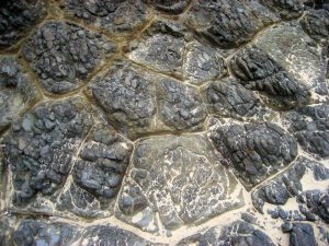
The basalt outcrop represents a deep ‘river’ of red-hot molten lava that filled a former valley in the underlying Strzelecki sediments. As the rock cooled it solidified and then contracted forming cracks that initially resembled three-pointed stars that formed polygons when they grew—a bit like mud cracks. However, these polygonal cracks then grew downward from the surface through the entire rock to form columns. The length of the columns indicates the thickness of the lava flow.
You can see that the columns are about 60 cm across and generally hexagonal. Notice that the rock within each column is fractured into smaller pieces forming a collection of rounded ‘onion’ shapes that look like a cobbled road-surface.
Creek deposits
Immediately to the south of the steps, before reaching the sandstone outcrops, the embankment exposes loose, friable material that is likely a deposit from flowing water (fluvial deposit) and probably post-Flood. A small creek runs onto the beach just alongside the sandstone outcrop. Use the wooden stairs to see the course of the creek along the top of the headland.) The small creek and the little bay forming Bonwicks Beach are eroded along the contact between the base of the basalt and the underlying Strzelecki sediments.
Beach sand
Note the sand on Bonwicks Beach, its composition, size, and shape of the grains. Compare and contrast the sand on the beach with the sand in the sandstone rock platform. Where did the different sands come from? How far have they been transported and for how long? Check the beach sand for ripple marks and animal footprints. What would it take to preserve these marks as a rock? Check also for patterns of erosion produced in the sand by seepage and small streams. Imagine these patterns were hundreds of times larger—the size of mountain ranges and valleys—and think about how these processes could explain how landforms could be produced. Notice how the sand on the beach sits on top of the sandstone and basalt outcrops indicating that the beach deposit is younger than both. This is how geologists work out the relative ages of different rocks.
Cape Woolamai
From this site you can have a good view of Cape Woolamai. Notice the shape of the granite pluton, how the land rises abruptly from the ocean and the topof the cape slopes to the north. Notice the huge sand deposit connecting the granite to Phillip Island, forming a tombolo structure. You should be able to see the pink colour of the granite along the distant shore.
Granite monument
At the top of the stairs near the carpark is a small granite monument commemorating George Bass and his voyage in the whaleboat. The monument will allow you to get a good look at the mineral structure of granite. Look for the three main minerals, quartz (grey, translucent), orthoclase (pink) and plagioclase (white). See how the minerals are interlocking—they are not just pushed together like sandstone. Notice that the granite also contains a black ‘accessory’ mineral.
Significance
This site gives a good understanding of the relationship between the Strzelecki Group, the overlying basalt, the creek deposits and the modern beach sand. It illustrates the way geologists determine the timing of different geological events. It shows the involvement of water in the deposition and erosion of the various rock units and the magnitude of the lava flows. The sediments, including conspicuous beds of conglomerate containing pebbles of Cape Woolamai granite, point to a period of extensive erosion after the emplacement of the granite.
Guide available as a booklet
This entry is taken from the geological excursion guide for Phillip Island. The complete guide is available as a booklet on creation.com Aussie store.
Abby Mydino
So it’s possible to find the real dinosaur fossil here?
Tas Walker responds: Dinosaur fossils have been found in the the sediments of the Strzelecki Group further to the east of Kilcunda.