From the car park at the Woolamai Beach Surf Lifesaving Club at the end of Woolamai Beach Road you can take a few different walks.
Site 9: KEY SITE. Along the beach to the first rocky outcrop of granite and return. (About 3 kilometres return ~1 ½ hours)
Site 10: Along the top of the peninsula south past the mutton bird rookeries to The Pinnacles and back. Access to the track is up wooden steps along Woolamai beach. (About 4 kilometres return ~2 hours)
Site 11: Along the top of the peninsula right around the Cape along the Cape Woolamai Granite Quarry Loop. Access to the track is up wooden steps along the Woolamai Beach. This loop passes the Pinnacles and the highest point on Phillip Island, which has excellent views. It also passes Gull Island, offshore, and has a side branch to the old granite quarry, which is in a secluded bay. (About 8 kilometres return ~4 hours)
Site 12: Along the top of the peninsula, first south and then east and north east to the old granite quarry near Red Point. Access to the track is up wooden steps along Woolamai beach. (About 5 kilometres return ~2 ½ hours)
Site 9 is one of the three so-called KEY SITES identified in the excursion guide. By visiting and understanding these three sites you will have a good appreciation of the geology of Phillip Island and southern Victoria. The three sites are:
- Site 6—Pyramid Rock;
- Site 9—Cape Woolamai Beach and
- Site 13—Bonwicks Beach, San Remo.
These three sites are suitable for individuals and groups (such as a school excursion or church youth group). All three could be visited in a morning or afternoon.
General
Note that the cliffs are steep and dangerous so care needs to be taken to ensure your safety. Keep away from the edges of the cliffs and do not try to climb them.
Cape Woolamai is a huge granite rock outcrop that forms the most easterly point of Phillip Island and also the highest. It was once a separate island but is now joined to Phillip Island by sediments and sand dunes. A rocky island joined by sand to the mainland is called a tombolo.
You walk alongside the dunes when you walk along Woolamai Surf Beach from the car park (check the geological map). Are the dunes a late-Flood or post-Flood deposit? Check the structure of the sand in the sand embankments as you walk along the beach. Woolamai Hill (112 m) is the highest point on Phillip Island. The surface of the cape slopes gradually towards the north at an average angle of 5°.
Notice that the upland surface of Cape Woolamai is also covered by sand dunes. Some of the sand is composed of limestone (calcareous) and other is of quartz (quartzose). The sand dunes are aligned in parallel sets of dunes that face a couple of directions. The direction of the dunes seems to be related to the direction of the underlying joints in the granite and not to the direction of the wind. These upland dune features are unique in Victoria. Were these sand dunes deposited during the Flood or afterwards?
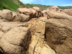
The rock comprising Cape Woolamai is a pinkish coarse-grained granite and well exposed in the coastal cliffs. The granite body has many straight parallel cracks that pass through the rock (called joints). The joints run in a few preferred directions and cut the rock into smaller pieces, like a potato is cut into long, vertical potato chips. You can appreciate this jointing in the coastal cliffs where you can see how the rocks are broken. The jointing has determined the orientation of gutters and deep clefts that have been eroded in the cliff face and at its base. The joints are also responsible for the remarkable shapes of the exposed rocks. The pyramidal rock stacks and large boulders on the exposed coastline are typical. The Pinnacles are one spectacular example of the shapes produced by these joints.

When you are looking at a piece of granite, see if you can get a good view of the mineral structure. Look for the three main minerals, quartz (grey, translucent), orthoclase (pink), and plagioclase (white). See how the minerals are interlocking—they are not just pushed together like sandstone. Notice that the granite contains a black ‘accessory’ mineral too (possibly a mica or a biotite mineral). See if there are any ‘imperfections’ such as a xenolith (‘zen’-o-lith’, e.g. a darker area on the stone or an area with a smaller grain size, or some other foreign rock that is embedded in the granite). See if there are any filled cracks/lines/zones on the rock (usually pinker and finer grained), which represent where the rock cracked and was refilled with the remaining pink molten magma. These are called aplite dykes. Check the skin of the granite boulders to see how they are of different texture from the inside of the boulder due to weathering.
Notice the composition of the sand on the beach and on the upland plateau of the Cape.
Site 9: Woolamai Beach
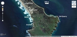
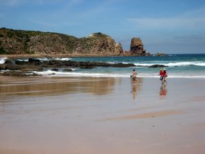
Walk south from the car park at the surf lifesaving club along the beach to the first rocky outcrop of granite and return (About 3 kilometres return~1 ½ hours). Be aware of the state of the tide and make sure you do not become trapped on the rocks by the incoming tide.
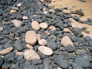
This is a long walk along a beautiful beach that has many interesting geological features to examine. The most southerly point visible is called Pulpit Rock. Check the structure of the sand in the steep sand embankments of the tombolo as you walk along the beach. The first rock outcrops that you encounter are pale coloured. They are not granite but highly altered basalt. You can still see the polygonal (often hexagonal) shape of the basalt columns.

Keep an eye on the steep bluff along the beach and watch for the contact between the overlying sandy sediment and the underlying rocks. These contacts between the different rocks are always interesting to inspect. Further along the beach you will encounter distinctive pink granite outcrops. The presence of the granite will first become obvious as isolated pink boulders mixed with the black basalt ones.
Notice the mineral structure of the granite. The rocks have been weathered and the minerals stand prominent making the surface rough. You should be able to distinguish the three minerals comprising granite: quartz (grey, translucent), plagioclase (white), and orthoclase (pink). In freshly broken surfaces of granite you should be able to see the flat crystals of plagioclase and orthoclase sparkle in the sunlight.
Look for cracks in the granite that have been filled with more pink lava forming what is known as aplite dykes. Some cracks are narrow and others wide. The aplite dykes have a fine mineral structure and smooth, flatish surfaces, which contrast the rough, rounded surfaces of the coarse-grained granite. There are a number of long dykes running through the granite outcrops.

Site 12: Old quarry
Commencing in 1891 with 100 workers, the pink Woolamai Granite was quarried for building stone. The workers drilled holes in the granite into which they placed wooden pegs. When the tide came in, the water would swell the pegs and split the blocks, some of which weighed as much as 5 or 10 tons. Ships came into a granite jetty at high tide and when the tide went out the blocks were loaded onto the ship with trolleys and a crane. Once refloated at high tide, the ship would sail for Melbourne.
Quarrying ended not long after the ship Kermandie disappeared at sea on 10 December 1892, loaded with granite. You may be able to see blocks of granite still stacked at the old jetty. It is said that the Equitable Life Assurance building was the only Melbourne building constructed from Cape Woolamai Granite.
Mutton birds
Cape Woolamai is home to a large colony of short-tailed shearwaters, otherwise known as mutton birds. These migratory birds fly from Japan, Alaska, and Siberia, to arrive late in September and breed. They return to their old burrows and, after cleaning them out, lay their eggs in late November. The chicks hatch in late January and grow rapidly until they are heavier than their parents. The adults leave on their migration two weeks ahead of their chicks, which depart in late April.
Origin of Granite
Granite is a light coloured rock rich in aluminium and silica, contrasting with basalt which is black coloured and rich in iron and magnesium. Both solidified from magma (molten rock) but the magmas originated from different sources. Granite is thought to have originated from the melting of continental crust whereas basalt originated from the melting of the mantle underneath the crust.
Tectonic movements fold and compress the source rocks, partially melting them. The pressure squeezes out the molten magma leaving behind a metamorphosed rock. You have probably heard that granite takes millions of years to form but in recent decades geologists have changed their views and now believe it happens catastrophically. The metamorphic melting and magma separation happens rapidly. The magma is squeezed out quickly and transported rapidly to the surface through vertical cracks in the crust.
In the process the granite can pick up pieces of the surrounding rock and these become included as xenoliths (foreign rock). The granite solidifies and cools quickly due to the release of fluids from within the magma chamber and the presence of fluids around it. Even the large crystals in granites do not need long periods of time to form but can grow in minutes depending on the water content of the molten magma as well as the temperature and pressure conditions.
Significance
You can have good understanding of the relationship between the Older Volcanics, the Woolamai granite and the large sand deposits forming the tombolo. This illustrates the way geologists determine the timing of different geological events. From geological sites like this geologists can see that there was considerable erosion to expose the granite at the surface before the basalts were erupted. The erosion was immense because all the sediments that the granite intruded into, and which sat on top of it, were eroded away. Were there some sediments of the Strzelecki Group that were eroded away or were these sediments never deposited in this area? More likely they were eroded away. The site shows the involvement of water in the deposition and erosion of the various rock units and the magnitude of the lava flows. This site suggests that the granite magma was emplaced into the sedimentary rocks as the waters of Noah’s Flood were rising and the crust of the earth was moving. The basaltic lava was erupted as the floodwaters were receding from the continent into Bass Strait.
Guide available as a booklet
This entry is taken from the geological excursion guide for Phillip Island. The complete guide is available as a booklet on creation.com Aussie store.