I’m finding your site fascinating. I live in Kurrajong Village [in the Blue Mountains north-west of Sydney, Australia] and was wondering where exactly the fault in my area runs? Do you have a map with the streets and roads marked on it?
My reply:
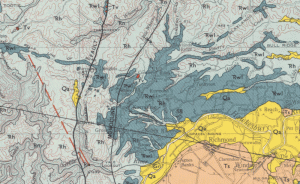
I’ve posted an image here showing the location of the fault. The image is from the 1:250,000 scale geological maps number si5605. You can download the complete map from the Geoscience web site. (You have to click on the correct rectangle to get the correct map.)”

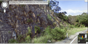
On this image (see left) from the street view from Google you can see the cutting. When you look at the cutting from the RH (north) side of the road you get a good view of the strata comprising the Hawkesbury Sandstone, and you can see how the strata turn downwards as a result of the Kurrajong Fault, as you move along the cutting at the western end. The strata are not so clear in this photo.
The Hawkesbury Sandstone in the image would have been deposited toward the middle of Noah’s Flood as the waters were rising.