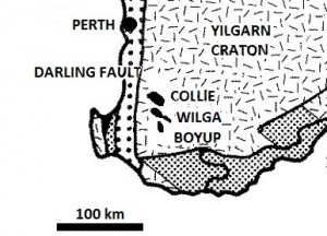
Is there any evidence that these sediments once covered the plateau? Perhaps there are some erosional remnants that have been left on the top of the craton. We would be looking for sediments that were classified toward the bottom of the pile (Silurian, Devonian or Permian) not sediments that were from the top (Cretaceous or Tertiary). (See the section on the article about Perth geological cross-section.)
There are remnants of Cretaceous sedimentation on the Yilgarn Craton but this is not what we are looking for. We are looking for sediments that are classified of a similar ‘age’ as the base of the sediments in the Perth Basin. We keep in mind, of course, that the ‘ages’ assigned to the sedimentary layers based on the fossils need not necessarily represent an exact time correlation over the distances involved since the sediments do not represent in situ environments but areas of deposition from water that has flowed a large distance during the Inundatory stage of the Flood.
Indeed, we do find some impressive sedimentary deposits that have been preserved on the plateau. The booklet Coal Western Australia published in 1990 by the Geological Survey of Western Australia1 describes three ‘basins’ toward the south west of the Yilgarn craton. These are the Collie, Wilga and Boyup basins which are about 45 km east of the Darling Fault on edge of the craton and about 100 km south of Perth (figure 1). These deposits are classified as Permian which is similar to the strata at the base of the sediments in the Perth Basin. This is exactly what we are looking for.

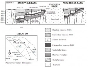
(from ref 2). Section 3 only is shown.
We see from the cross section (figure 2) that that the strata in the Collie Basin terminate abruptly at the faults. They have also been planed off at the ground surface. It is clear that these sediments were once part of a much larger deposit of sediments that covered a significantly greater area of the Yilgarn Craton. That was before the Yilgarn Craton was faulted and its surface eroded.
Similar sediments are also found in the Wilga and Boyup basins which lie 30 km and 45 km south of the Collie Basin. The booklet1 says these basins, “like the Collie coalfield, are relics of an areally extensive Permian succession that has been preserved in fault-bounded grabens on the Yilgarn Craton.”
From our assessment of the Perth geological cross-section, we conclude that these sediments were not only greater in areal extent but much greater in thickness on the craton. They were eroded away by the receding waters of Noah’s Flood. However, the downfaulted grabens preserved a remnant of them still at the surface. This has implications for the timing of the downfaulting.
It’s exciting to see how the biblical model based on biblical history throws light and insight into understanding the geology of a local area such as the Perth area of Western Australia.
References
- Coal: Western Australia, Department of Mines, Geological Survey, Perth, 1990.
- Varma, S., Hydrogeology and Groundwater Resources of the Collie Basin, Western Australia, Water and Rivers Commission, Resource Science Division, Hydrogeological Record Series, Report HG 5, 2002
Eromanga Sea: Noah’s Flood covered Australia
[…] The sea covered the whole of Australia, not just a proportion of it. In the above diagram,geologists show the extent of the inland sea according to the extent of the sediments that exist now. From the diagram we see there was a lot of Australia that was supposedly not covered with water at this time. However, the sediments covered a much greater area in the past. Kilometres of thickness and vast areas of sediment have been eroded away. This happened later in the Flood, especially as the floodwaters receded from the land (see discussion on Perth geology and Collie basin). […]