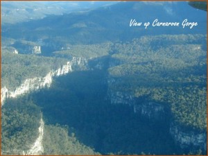
The towering walls of the Gorge expose sediments from the Surat Basin, which hosts abundant gas and oil reserves in other parts of the state. The most prominent feature in the Gorge is its brilliant, white cliffs of Precipice Sandstone—the lowermost member of the Surat Basin. Like a blanket, these sediments cover a large part of eastern Australia (See Sedimentary blankets). They were deposited towards the middle of Noah’s Flood as the waters were rising on the earth and nearing their peak (See Carnarvon Gorge geological history).
Sediments from the uppermost member of the Bowen Basin form the floor of the Gorge. Because the Moolayember Formation is relatively impermeable water from the springs of the Gorge remains close to the surface, making the Gorge an oasis in the arid country. The Bowen Basin extends to the north and east, and has rich coal deposits. This basin was also deposited during Noah’s Flood, earlier than the Surat Basin (See Carnarvon Gorge geological history).
Basalt caps, up to 300 metres thick, sit high above the gorge on either side. These are part of the Buckland Volcanic Province and form the Consuelo Tableland, atop the north wall, and the Great Dividing Range, to the south. Boulders eroded from the basalt dominate the waterways of the gorge. The hot basalt lava flowed across the sandstone plateau after the floodwaters had reached their peak and just started to recede from the continents. It was subsequently disected by the receding water. (See Carnarvon Gorge geological history).
There is much evidence within the sedimentary themselves that point to rapid deposition, such as thick strata, cross bedding and an extensive geographical extent, consistent with Flood deposition. However, the erosion of the Gorge provides even more dramatic evidence for Noah’s Flood, and I plan to discuss this in future blogs.
Note
1. Carnarvon Gorge is widely quoted as being 30 km long but from Google maps it’s more like 22 km, as the crow flies.
Related Articles
Carnarvon Gorge, Australia: monument to Noah’s Flood
Carnarvon Gorge rises above the waters of Noah’s Flood
Rainfall catchment for Carnarvon Gorge is not large enough
Carnarvon Gorge was carved in two stages
Landscape around Carnarvon Gorge was eroded in sheets by retreating floodwaters
Carnarvon Creek flows through a water gap carved during Noah’s Flood
The geological history of Carnarvon Gorge, Queensland, Australia, from a biblical Flood perspective
Landscape around Carnarvon Gorge was eroded in sheets by retreating floodwaters
[…] Carnarvon Gorge, Australia: monument to Noah’s Flood Carnarvon Gorge rises above the waters of Noah’s Flood Rainfall catchment for Carnarvon Gorge is not large enough Carnarvon Gorge was carved in two stages Landscape around Carnarvon Gorge was eroded in sheets by retreating floodwaters Carnarvon Creek flows through a water gap carved during Noah’s Flood The geological history of Carnarvon Gorge, Queensland, Australia, from a biblical Flood perspective […]
Russell Wallace
Tas,
A fascinating article. Makes much better sense of the evidence. MAny years ago I worked near CG. It is a very pretty area. Russ
R. Fortey
Since the Buckland Volcanic Province has been dated at about 30 million years old, this presumably means that Noah’s Flood had to have happened more than 30 million years ago, thus extending human history at least a thousand times.
Tas Walker responds:
Oh the dates, the dates. I mention the millions of years in the article about Carnarvon Gorge rising above the water. You have to get past that sticking point before you can think outside the box. Check out The way it really is: little-known facts about radiometric dating and How dating methods work to see that you don’t have to accept the million of years literally.
Steve D.
Hi Tas,
Thanks for sending this out. I check your website regularly and read your new blog posts when you post them as well. Your links to the left, especially the book links and your review of these books: ‘The Dating Game’, ‘The Man who Found Time’, ‘The Map that Changed the World’ have been especially helpful as I have read all three since seeing them on your website. It has given me a much broader understanding of the history of geology, sparking my interest to keep abreast of developments in this exciting field.
Kimbal B.
Dear Tas,
I often tell people to go to your blog to get a basic understanding of geology from a Creationist perspective and to understand the sedimentary rock layers in light of the Noahic Flood. Your articles make regular appearances on my radaractive blog (attributed of course). Thanks for all you do!
Al K.
Hi Tas-

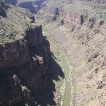
Reminds me of the Rio Grande gorge in New Mexico. This is the same river that eventually forms a boundary with Mexico but in New Mexico, it has cut this in a plateau which you can see at the top of the picture.
Jennifer
thank you for this article – a pleasure to continue learning, and praising the Lord, with your articles!
Jim Hooper
I once read old Babalonian reords shows sun rising in west and one planet less. He comented that when it came into place it was so close to earth and turned it to reverse the opposite way and this caused the much rain and waters of the seas washing over the land causing the Noahs flood. I am told in the British and Greek museums are 2 old clay “tablets”. One has on it “Here the first man lived” and the other no writing but a Man looking down and jaded followed by a woman followed by a snake with a ball in its mouth. So Genesis story has been around for a long time. Jim Hooper
A.N.
Further to your article on Carnarvon Gorge in reference to the extent of artesion water in Queensland.
1. Would most of this water have been trapped in the Zenthic Phase continuing in the Abative phase.
2.The movement of water between the sandgrains is suggested at the rate of 1-5metres a year dissolving certain salts.
3.The temperature apparently rises because of pressure.
4.Are there any further studies on Artesion-Sub Artesion Water?
Many Thanks,
A.N.
Tas Walker responds:
I presume you are referring to the article about the geological history of the Carnarvon Gorge, where it talks about the sediments deposited during the Inundatory stage of the Flood.
1. Yes, most of the water would have been trapped when the sediments were deposited during the Zenithic phase.
2. Yes, movement of water is considered to be slow, as you indicate, but I don’t have the exact numbers for the rate of flow.
3. The temperature is considered to rise, not because of pressure but, because of depth due to the heat transfer through the crust.
4. Yes, there would be many studies. Google “great artesian water Endersbee” and you will find some, such as: The Great Artesian Basin Protection Group. In that article it says,
You will have to do your own research to see what else is published about it.