
At the southern end of Kitty Miller Road there is parking at Kitty Miller Bay from where you can visit three points of interest. The first is Kennon Head described at Site 3. The second is Kitty Miller Beach and rocky outcrops to the east described as Site 4. The third is further east. on the other side of Watt Point from Kitty Miller Bay, where the wreck of the SS Speke can be seen. It is a reasonably difficult walk/climb to reach the area. You can continue east over the rocks around Watt Point but the rocks are uneven and progress is slow. Or you can walk over the grassy headland with access to the track from Kitty Miller Beach. You will need to make your way down the sandy bluff to the beach and shore platform beyond Watt Point and this is quite steep. You need to be careful whichever way you go. (About 2 kilometres return ~1 ½ hours return).

The SS Speke was shipwrecked at Watt Point on 22 February 1906 in a fierce gale.
Of particular interest is a small outcrop of Cambrian greenstone further east just beyond the wreck.1 These rocks cover such a small area that they are not marked on the geological map.
The greenstone is exposed on two small rocky promontories and on the shore platform. The outcrop is about 250 metres wide and begins from a position 70 metres east of the wreck of the SS Speke. The greenstone can be seen in the first small promontory beyond the wreck. It is approximately 10 metres high and has a beach frontage in this promontory of 85 metres. Further west, after a stretch of about 65 metres of beach that is covered with sand and boulders, a second promontory has outcrops of the greenstone that is capped by a chert-like (flint-like) rock. Sporadic outcrops of the greenstone occur in the low, grassed cliffs between the promontories.
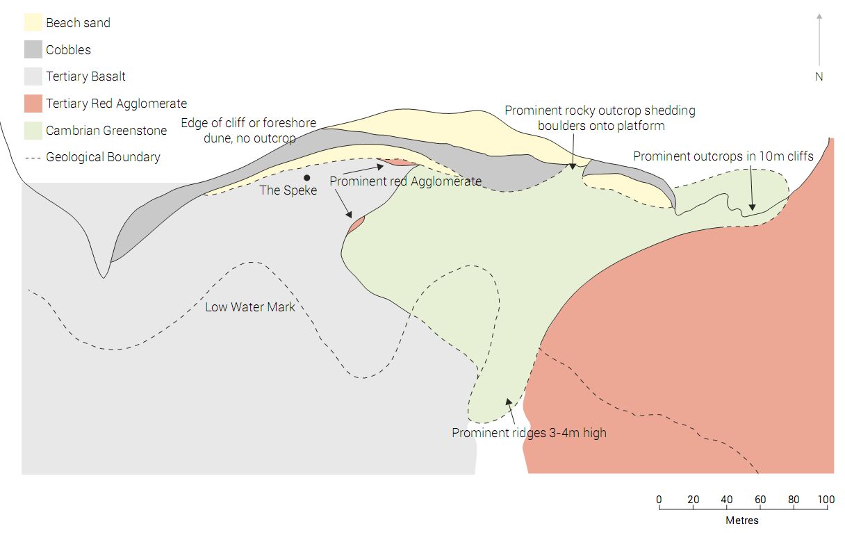
The greenstone is metamorphosed basalt lavas that are now greenish grey, fine grained, and hard. The outcrops contain many joints and the texture ranges from flint-like (with patches and veins of the minerals quartz, green epidote, and white albite) to granular.

Notice that to the west of the greenstone a layer of black basalt, some of which is vesicular (i.e. with holes), overlies the red agglomerate. This basalt forms the horizontal shore platform to the west of the greenstone. Dark brown onion-weathered basalt with large-scale polygonal jointing overlaps fine-grained greenstone, forming the western boundary.
Much of the shore platform is covered with rounded pebbles and cobbles, mainly of basalt from the Older Volcanics but with some greenstone. Notice too that boulders of medium- to course-grained dark greenstone are occasionally found on the shore platform but their source is not exposed even at low tide. These are interpreted as gabbro or ultramafic volcanic rocks that have been altered (metamorphosed) by metamorphic process involving much heat and water, producing a rock called serpentine.
Significance
The Cambrian greenstone gives us a tiny window into some of the rocks deposited early during Noah’s Flood, showing how they have been altered and fractured. This indicated crustal movements occurred after the rocks were deposited. For the Older Volcanics rocks to be deposited directly on top of the Cambrian outcrop indicates that lots of erosion occurred prior to the eruption of the volcanics, and this would have occurred during the Flood as the waters were rising. The agglomerate deposits show that the basalt lava erupted over the landscape in the midst of flowing water and sedimentation—a situation that is consistent with the Flood.
Reference
1. Henbry, D.A. and Birch, W.D., Cambrian greenstone on Phillip Island, Victoria, Australian Journal of
Earth Sciences 39:567–575, 1992.
Guide available as a booklet
This entry is taken from the geological excursion guide for Phillip Island. The complete guide is available as a booklet on creation.com Aussie store.