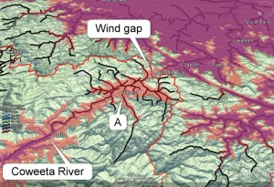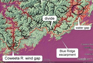
These pictures are of the border between the Coweeta River and its adjacent watersheds. The Cullasaja River is a tributaryof the Coweeta River, located to the east of it, and flows towards the north.
In the first image, the divide between the Coweeta River basin and the neighboring Savannah River waterhsheds is shown as a red line, with the Coweeta basin to the left of the divide. Elevations below 700 m are in pink, and below 630 m are in purple. The image shows a wind gap between the two basins. This is indicated by an arrow where a pink connection runs across the red line of the divide, demonstrating a former connectivity between the two basins.
The problem for Gallen et al. is explaining the formation of the wind gap in their model. The gap is erosional, that is, formed by water, though its orientation may have been influenced by faulting. In addition, the angle of tributary “A” suggests that it used to flow toward the gap, because tributaries have a V shape in the downstream direction, whereas this one is “V-ing” upstream. Similar V-shapes have been used by other geologists to argue for stream rearrangement to the north of this area.
It could be postulated that the Coweeta captured the tributary from the Savannah watershed, but stream capture is thought to be favored by a steep slope on the side of the capturing stream, which is not the case here. In fact, the steepest slope is on the Savannah side of the divide, which should suggest that it should be doing the capturing, not the other way around.

Note in the second image that the Blue Ridge Escarpment does not coincide with the drainage divide—another problematic feature of the area (see this link on the Origin of the Blue Ridge Escarpment, southern Appalachians for more information).
UPDATE 26 February 2013:
Following feedback from Sean Gallen this article and the images have been updated to correctly identify the river shown on the images. What is now labelled as the Coweeta River was previously labelled as the Cullasaja River. The Cullasaja River is a tributary of the Coweeta River, located to the east of it, and it also flows towards the north.
Robert Walsh
Tas, I was very happy to see the respectful discussion from the primary author. It is refreshing to see that one who holds to an evolutionary worldview be so gracious rather than caustic. He fundamentally disagrees with the Biblical position, but showed restraint and grace to you and the audience.
Keep up the good work!
Jennifer Honda
🙂
sake
Why is it that all erosional evidence put forth by creationists always map to (according to non-creationist geologists) ancient mountain chains, but never newer ones like the Himalayas, the Alps or the Dolomites. Standing at their respective (high) altitudes, did they escape flooding altogether? Or, if not, how do you explain this descrepancy of strong flood associated (your claim) erosion in some (I say older) rock, but none in other (I say younger) rock?
Tas Walker responds:
Hi sake, The erosional evidence works with all mountains. This article Do rivers flow through mountains shows that water gaps are found all over the world. You can see them for yourself with Google Earth.
Dan.W.
It was while I was studying geology at College in the UK in preparation for my entrance to University College Oxford that I realised the interpretation of the findings of the observed rock formations and structures was unsound. This led me to a generalised distrust of modern scientific interpretation of discoverable data. Now, 55 years later, I have discovered nothing that would prove me wrong. I hope that you find this website as interesting as I do.
As I understand it no Australian universities have a chair of geology any more but it is exciting, to me, to know that such an understanding as this is now available from Australian sources. Praise God for the Genesis record because frankly it is the truth. Cheers Dan