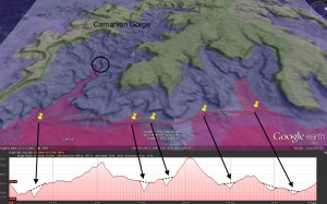
The blue sea level is set at 880m asl, and clearly delineates the flatness of the Consuelo Tableland. Carnarvon Gorge is the embayment at the left of the image, containing a violet finger at 510m asl. The circle indicates a knickpoint1 transition between two surfaces. The lower profile belongs to the red line drawn along Clematis Ridge. It is about 17 km long, and shows at least 5 water gaps along the way. The gap furthest to the left is the entrance to the gorge.
I think we will see in the future that Google maps and Google Earth will provide a great tool for geologic research! It’s the sort of thing that could be used with a school project. Students could easily investigate and publish (on a blog) original research into one of the multitude of amazing localities on Earth.
Note
1. Knickpoint is a term in geomorphology to describe a location in a river or channel where there is a sharp change in channel slope, such as a waterfall or lake.
Basalt flows around Carnarvon Gorge, Central Queensland, erupted under water
[…] Geological map showing Tertiary basalt from area just north of Carnarvon Gorge. Width of map approx. 38 km.The Consuelo Tableland to the north of Carnarvon Gorge would have been one of the first areas of land to emerge in Queensland as the waters of Noah’s Flood were receding from Australia. A rough calculation shows it would have been at least 224 days after the Flood began before the tableland emerged. The receding floodwaters carved the remarkable landscape around the tableland, including Carnarvon Gorge, when they drained from the land as the tableland emerged. […]