Floodwaters rise

Tectonic movements in the earth’s crust compressed these deposits in an east-west direction, and uplifted them, producing huge faults and folds in the strata. The strata were pushed onto each other and shortened by the compression. Mineral laden fluids within the sediments squeezed out through faults and cracks and released their dissolved booty, including gold, in mineralization areas which are now mined.

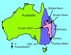
As the floodwaters continued to rise on the earth, sediment, ripped-up vegetation and the remains of animals were deposited onto different areas of the continent of Australia, areas that geologists call basins. These include the Galilee, Cooper and Bowen Basins in Queensland and the Sydney Basin in New South Wales (figure 2). It’s likely that these basins were connected and, even as the floodwaters were rising, channeled huge volumes of water off the continent and into the ocean to the east. In Queensland and New South Wales these rocks have been classified as Permian and Triassic.

None of these large sedimentary basins is represented in Victoria.
Floodwaters peak

Geologists have recognized this period of erosion in Queensland and New South Wales and assigned it to the Tertiary period. The ocean basin sank downward to the east along a north-south hinge line that now forms the Great Dividing Range. The receding floodwaters therefore tended to flow from the west to the east into the Pacific Ocean.
However, in Victoria the ocean basins sank downward to the south (along a hinge that runs east-west in Victoria). The floodwaters from the north would have run in a southerly direction into Southern Ocean. These receding floodwaters initially planed the land in Victoria relatively flat and this is recognized as occurring from the Permian to the Jurassic.2

While the floodwaters were receding, volcanic eruptions occurred, caused by tectonic movement of the earth that released molten lava and forced it to migrate through the earth to the surface. In Victoria these eruptions are known as the Older Volcanics and they cover most of Phillip Island. Similar basaltic eruptions occurred all the way up the east coast of Australia into far north Queensland.
In the northern states very little sediment was deposited after these eruptions (although much erosion continued to take place). However, in Victoria abundant volumes of sediment were deposited after the voclanics including sandstone, limestone, conglomerate and coal, such as the huge brown coal deposits at Yallourn and Baccus Marsh. Perhaps this continued sedimentation was because the floodwaters stopped draining east from central Australia long before they stopped flowing south through Victoria. The change in water drain-off was likely the result of the uplift of the Great Dividing Range in Queensland and NSW.
In the late stages of the Flood the receding floodwaters were still powerful enough to erode rock from the landscape, including the quartz reefs within the folded rocks, reefs that contained gold. These gold-bearing conglomerates and gravels were deposited in valleys and have become known as ‘deep leads’, which have a long history of being mined for alluvial gold in Victoria.
After the Flood
After the floodwaters had receded, the continent was vegetated by seeds and plants left on the surface. The oceans and waterways were colonised by marine animals that were left in the waters on and around the continent after the Flood. However, the air-breathing land animals that now live in Eastern Australia migrated from Mt Ararat in the Middle East, probably using land bridges through the Indonesian Islands. Humans would likely have been responsible for much animal migration, using boats as well as land bridges. Landscape erosion, sedimentation and volcanic eruptions have occurred in the 4,500 years since the Flood, but these were minor compared with what happened in the catastrophic year of the Flood itself.
References and Notes
- This history was prepared for the CMI Supercamp on Phillip Island in January 2009. In preparing this geological history I have drawn on Abele, C., Explanatory Notes on the Queenscliffe 1:250000 Geological Map, Geological Survey Report 1977/5, Mines Department Victoria, pp. 1–3, 1977.
- My aplogies for not labeling Melbourne or Phillip Island on these figures. For international readers, Melbourne and Phillip Island are on the south coast of Australia, north of the island of Tasmania, just where there is an indent in the coastline.
- Linking the Permian-to-Jurassic planation in Victoria to the Recessive stage of the Flood means that the Cretaceous sediments in the Otway and Gippsland basins were deposited during the Recessive stage. This contrasts with the Cretaceous sediments in the Great Artesian basin in Queensland and NSW which have been interpreted as being deposited during the Inundatory stage of the Flood (see Walker, T., The Great Artesian Basin, Australia, Journal of Creation 10(3):379–390, 1996). The question of whether these sediments were deposited as the waters were rising or falling is one that needs to be investigated further before coming to a definative conclusion.
Mrs. J.Clemons
I know very little about Austraila’s geography, and found it to be very helpful just for general knowledge. Wish you could have labled a little more for the ones who are not familiar with the locations of the various places that you have described i.e. Victoria is ? where ? Aside from that the drawings and labels that were given were very helpful. Thanks a lot.