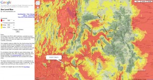
It’s been prepared in response to Berend de Boer’s comment, and illustrates what can be done with Sea Level Rise. This image of the western US has the sea levels set at 1650m asl (red), 1850m asl (orange) and 2100m asl (yellow), and that illustrates the effects of the receding floodwaters as the continents rose and the sea levels dropped.
As you can see, a huge swath of the western US has become a giant inland lake, whose only outlet is the Grand Canyon. This would appear to correspond to the inland lake that Scheele mentioned in his article. What is interesting is that the higher sea levels appear to the north, which would seem to indicate that drainage started toward the north and proceeded southward. You can also see many large scale water gaps, indicated by arrows. On the acutal SLR website it is possible to zoom in and see the features in greater definition.
Kenneth Karle used a similar approach for the eastern USA and examined the multitude of wind and water gaps in the Appalachians. His article, published in Journal of Creation, is called Young evidences in an ancient landscape: part 1—the Eastern Structural Front of the Appalachian Mountains and is available free as a pdf.
Simulating the effect of Flood runoff by raising the sea level is a good first estimate to visualizing what happened. For water to flow there needs to be an hydraulic gradient, which means that the water level upstream would be higher than the level downstream. Also, as the waters were receding, the continents were rising relative to the ocean, and that involved massive tectonic movements. Such movements of the crust mean it’s likely there were localised changes in the level of the land surface during this process.
Nevertheless, as this image shows, the evidence for Noah’s Flood is not something confined to just a few specialist geologists. Anyone interested can now experiment with the amazing tools readily available on the web.
Joel Tay
Very interesting!
Don Kennedy
There is further evidence that this process ocurred and it is right under our noses. The maps from the 1600s that show California as an island were based on ancient maps made while this process was underway. I have shown how these maps are not myth and provide an accurate record of the coastline before the continent had been raised up. Please go to http:\\californiaasanisland.org for the whole story.