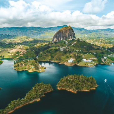
The Townsville Bulletin published on 2 March 2013 an item about the age of Castle Hill, the iconic landmark that overlooks the North Queensland city. Written by journalist Daniel Bateman, the article reported ages calculated by Dr Carl Spandler from the local James Cook Univeristy School of Earth and Environmental Sciences. (See Icon’s not [...]

Continue reading about Castle Hill much younger than James Cook University age reported in Townsville Bulletin

In response to my two recent posts, reader JS sent two Google-Earth images that provide further evidence the Appalachians were eroded by the receding waters of Noah’s Flood. My first post presented a reinterpretation of a paper published in GSA Today (a publication of the Geological Society of America) which examined the Cullasaja basin in [...]

Continue reading about Google Earth shows Appalachians were eroded by receding floodwaters

Sean Gallen, lead author of the GSA Today paper about the uplift of the Appalachians, which I connected with Noah’s Flood has responded with the following comment. My response is interspersed.
I am the first author on the article “Miocene rejuvenation of topographic relief in the southern Appalachians”. While my coauthors and I appreciate Tas’ interest [...]

Continue reading about Lead author challenges Noah’s Flood interpretation of Appalachians

An interesting article, published in GSA Today (a publication by the Geological Society of America) in February 2013, describes features of the landscape of the Appalachian Mountains. These are a system of mountain ranges in eastern North America, extending from around Atlanta, Georgia, north past New York, and into Canada (see figure left). The paper [...]

Continue reading about Appalachians eroded by receding waters of Noah’s Flood, new GSA paper shows

Reader JS sent some Google-Earth images of the Cape Town area, prompted by reading an article on Yahoo! News entitled African Mountain Range Could be World’s Strongest.
The researchers calculated erosion rates for the mountains based on measuring radioactive isotopes of beryllium. They calculated an unbelievably slow rate of erosion for the Table Mountain area, [...]

Continue reading about Google earth reveals ancient flow channels through mountains on Cape Peninsula south of Cape Town, South Africa

At the Mary Cairncross Scenic Reserve near Maleny, Queensland, the spectacular Glass House Mountains draw your gaze like a magnet. Photographs do not do them justice. You could spend hours soaking in the view as the clouds and shadows continually change during the day.
In this photo the scene is hazy because the atmosphere [...]

Continue reading about Mary Cairncross Scenic Reserve has stunning view of Glass House Mountains

Tas Walker on June 23rd, 2012

About 4,500 years ago, the African continent was entirely covered with water. We know this is true because humans witnessed the event, recorded what they saw, and the document they wrote is available to us today. About that water and its depth that account reads:
For forty days the flood kept coming on the earth, [...]

Continue reading about Geologists see effects of Noah’s Flood in Africa

On the shore at Sea Point, south of Cape Town, sits a dramatic geological contact (figure 1) that has been famous for some two centuries. This complex and spectacular feature was first described by Clark Abel in 1818,1 and then visited by the young Charles Darwin in 1836, on his journey around the world on [...]

Continue reading about Famous contact at Sea Point, South Africa, reveals rapid granite emplacement

The oldest rocks in the Cape Town area, South Africa, are part of the Malmesbury Group,1 named after the town of Malmesbury, 60 km north-west of Cape Town. The Malmesbury Group covers a large area around Cape Town: 200 km to the north and 100 km to the east. Beyond this they are covered by [...]

Continue reading about Cape Town’s oldest rocks deposited rapidly from abundant water

In the steep road cut alongside Chapman’s Peak Drive, south of Cape Town, South Africa, you can see some of the flat-lying beds of sediment that form the 1000-metre tall mountains along Cape Peninsula. The mudstone has a distinctive maroon colour while the coarser sandstone is buff. The road runs just above the contact between [...]

Continue reading about Cape Peninsula sandstones, South Africa, deposited during Noah’s Flood