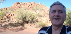
This prominent hill just north of the town of Kununurra in the Kimberley in Western Australia is called Kellys Knob (aka Thegoowiyeng). It rises some 190 metres above the surrounding plain and gives great views of the area around Kununurra. I’m at the car park, which is about halfway up.
The sediment that makes up the knob has been called the Kellys Knob Sandstone, and has been traced for more than 50 km. In some places it is more than 350 metres thick. It is one of 12 named formations within a much larger sediment formation called the Cockatoo Group, which was deposited in the Bonaparte and Ord Basins of northern Western Australia. In some places the thickness of the Cockatoo Group exceeds 2,700 metres.
Kellys Knob stands alone in the area, surviving an enormous period of erosion when kilometres of sediment were removed from the whole area, exposing the deeper rocks. This happened around the middle of Noah’s Flood when the whole region was covered by the floodwaters. Sheet erosion occurred first, and later, as the Australian continent was rising, wide channels were carved by the waters as they receded into the ocean.