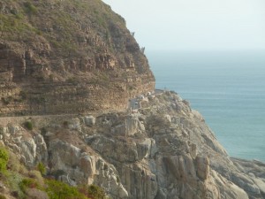
In the cut as you drive along the road you can see flat-lying maroon, purple and tan beds stacked like pancakes one upon the other. They continue up the escarpment peeking out from beneath the vegetation. These strata are part of a vast sedimentary blanket called the Cape Supergroup. Although this blanket has been folded and eroded, it still covers much of the southern portion of South Africa.
Underneath the road and plunging into the sea is a steep outcrop of granite. These smooth, grey, rounded rocks were once part of an enormous body of molten rock deep within the crust of the earth. That body is now called the Cape Peninsula Pluton, and is itself part of a larger group of granite outcrops called the Cape Granite Suite.
According to the Bible, the world experienced a global, catastrophic Flood about 4,500 years ago, and we can explain this landscape from that perspective. Mainstream geologists do not believe the global Flood ever occurred, so they use a different lens through with which to interpret the past. All the same, the careful observations they have made and the detailed reports they have written (e.g. see Further Reading below) help us understand the rocks and interpret them from a biblical perspective.
We need to realise that we are looking at just a tiny part of the evidence for the Flood. We are like ants in the grass; our perspective is limited as we try to understand the world around us. That is why it is so helpful to examine geological maps and geological diagrams that show us a bigger scale of what is present.
Briefly, as a result of movements in the crust, the granite was emplaced in large magma chambers kilometres in diameter under the earth early during the Flood. Ongoing movement of water across the earth during this catastrophe removed the rock above the granite. As the Flood continued, fast flowing waters deposited a great volume of sediment in gigantic, flat, sheets over the continent. The sea levels continued to rise and this made room for more sediment to be deposited until eventually the sediment pile reached an enormous thickness—more than 7 km in Western Cape.
Eventually, the floodwaters reached their peak. Further movements within the crust of the earth folded the sediments of the Cape Supergroup and deepened the ocean basins, allowing the floodwaters to flow off the continent. This eroded many kilometres of sediment from the landscape, depositing it at the edges of the continent on the continental shelves. The mountains alongside Chapman’s Peak Road, including Table Mountain, are erosional remnants, isolated rock outcrops that survived that remarkable erosional process.
Further reading
-
Compton, J.S., The Rocks and Mountains of Cape Town, Double Storey Books, 112 pp., 2004.
-
Theron, J.N., Gresse, P.G., Siegfried, H.P. and Rogers, J., The Geology of the Cape Town Area, Department of Mineral and Energy Affairs, Republic of South Africa, 140 pp,. 1992.
-
The sequence of geological events in the area around Cape Town is similar to the geologic sequence around my home city of Brisbane, Australia. See The Geological History of the Brisbane Area, Australia.
Tracey H
This time I was reminded of the great expanse of water, and the irrefutable evidence for it.
I think you would find the North East of England an interesting place, if you’ve never been! One of our most famous landmarks being the Whin Sill, along which Hadrian’s Wall is built, and upon which the castle on Holy Island (Lindisfarne) stands. Fascinating area. And not to mention the coal!
bryan
you can see a good book explaining all this on kindle called Noahs flood in southern africa