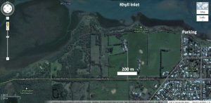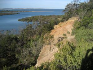
Park at the loop at the end of McIlwraith Road overlooking Rhyll Inlet. You can walk west on a path along the top of the headland. After about 600 metres you will reach a wooden boardwalk that allows you to overlook an old abandoned quarry. Unfortunately it is not possible to access the quarry face to see the rocks more closely. (less than 1 hour return)
Rhyll inlet is a major tidal inlet enclosed on the northern side by a long sand spit that extends for almost 5 kilometres eastward from Erehwon Point (near the Cowes jetty). Notice how the groves of mangroves shelter the beach. It may be possible to see some dark reefs extending as rock platforms into the inlet.
These reefs are the remains of basalt flows that have been mostly eroded away. In places the beach platform is covered by rounded cobbles derived from the break-down of the basalt. Saltmarsh deposits cover the beach platform in the sheltered sectors of the inlet. The marsh-covered platforms and rounded gravels that lie above high water mark possibly indicate a higher sea level relative to the land in the past.
Rhyll Inlet is a haven for myriads of sea birds and migratory wading birds. Watch out for pelicans, black swans, gulls, and ibis.

Safety! Do not try to climb on the face.
The local Council operated the Diamond Dolly Quarry between 1930 and 1940 to provide employment for the farmers and gravel for road making on Phillip Island. The sedimentary rock is composed of feldspar-rich (i.e. feldspathic) grits, arkose and thin mudstone beds. Arkose is sandstone that contains much feldspar (greater than 25%) in addition to quartz; it does not have a lot of fine clay sediment between the grains. Mudstone beds between the beds of arkose gravel made the quarried gravel less than ideal for road making.
Arkose is often derived from the breakdown of granite. Can you think of any granite in the area where the feldspar may have come from? The presence of so much feldspar in the sandstone means the breakdown and burial of the grains was rapid, before the easily weathered feldspar grains could disintegrate. The fact that the quarry was used for road gravel suggests that the deposits were friable and not strongly cemented into hard rock.
Geologists have designated the beds as Lower Cretaceous age based on the plant fossils found in the mud layers. Because the rocks are different from other Cretaceous rocks in the Western Port area geologists have given the beds here a separate formation name—the Rhyll Arkose.
Significance
This sand and gravel in this sandstone deposit point to rapid erosion of granite and rapid deposition before the feldspars disintegrated. The thickness of the strata points to deposition from deep flowing water, which is consistent with Flood deposition. Mud deposits have been generally interpreted as being deposited in still water, but recent research has found that mud will deposit from flowing water. The long sandbar enclosing Rhyll Inlet from the other side would be a post-Flood deposit. The basalt reefs indicate the geographical extent of the basalt lava flows.
Guide available as a booklet
This entry is taken from the geological excursion guide for Phillip Island. The complete guide is available as a booklet on creation.com Aussie store.