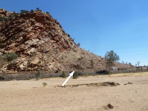
The strata of the Heavitree Quartzite slope upwards to the right (north) at about 40 degrees. They stop abruptly in mid air where they have been eroded away. This shows that the strata at one time extended much further to the north and would have completely covered the region where Alice Springs now is. These sedimentary strata are the first deposits of kilometres of depth of sediment that were washed over a huge area of Australia very early in Noah’s Flood. They were metamorphosed into super-hard quartzite and then pushed up, only to be eroded by the huge movements of water generated by the Flood cataclysm. That is why the sediments stop abruptly in mid air.
The sediments sit on top of the same metamorphic and igneous rocks that are exposed at Anzac Hill. As you can see, this area at the base of the steep cliff is mostly covered by loose debris, or scree. The igneous rocks are not obvious, but there is a small outcrop of these exposed at road level, as indicated by the arrow. This represents the contact between the Amadeus Basin to the left and the Arunta Block to the right. The Heavitree Quartzite shows astounding evidence of enormous flows of water, which is now considered to have covered most of inland Australia. Noah’s Flood was an enormous cataclysm.